
East Herts planners rate 12 Bishop's Stortford sites suitable for homes, 11 of them in the Green Belt. Councillors see the assessment on 11 November.
East Herts Council’s planners have rated 12 pieces of land around Bishop’s Stortford as suitable for new homes, and 11 of them are in the Green Belt. The ratings are in the council’s first land assessment for its new Local Plan, published with the agenda last week. Councillors on the District Planning Executive Panel discuss it on Wednesday 11 November.
The assessment does not allocate any land. It is a first, high-level check of the sites landowners and developers put forward in 2024. But it shows which fields on the edge of the town have passed the first test, and which have not.
The panel meets at 7pm at Wallfields, Hertford, and the papers are public (East Herts Council, District Planning Executive Panel, 11 November 2026).
What the assessment found in Bishop’s Stortford
Landowners and promoters submitted 21 sites in Bishop’s Stortford in the 2024 Call for Sites. Across the whole district there were 284 (Strategic Land Availability Assessment report).
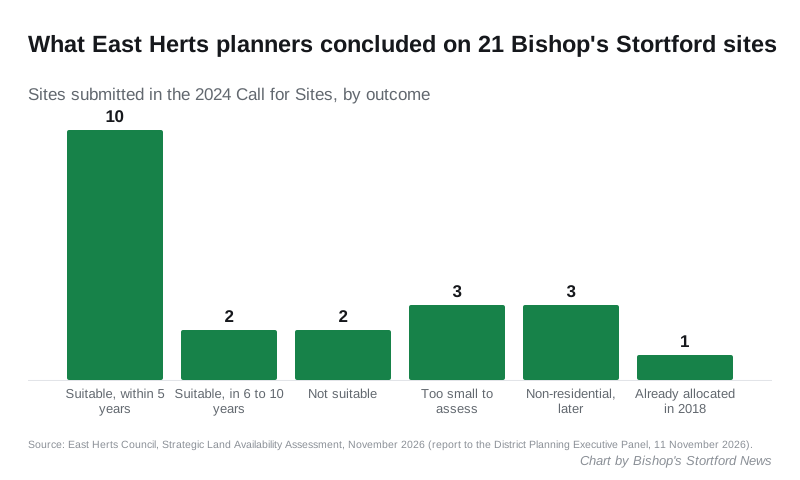
Seven were not assessed:
- three were too small, under the 0.25 hectare threshold
- three were put forward for uses other than housing, and will be looked at later
- one, Carrington House on Old River Lane, is already allocated in the 2018 District Plan
Of the 14 that were assessed, two were ruled out and 12 were rated “suitable subject to further assessment/mitigation”. Ten of those 12 were also judged deliverable, meaning they could be built within five years. The other two are large and would need major infrastructure, so they were rated developable in six to ten years (SLAA, November 2026, Appendix B).
The 12 sites rated suitable
| Site | Area | Green Belt status | Timescale |
|---|---|---|---|
| Apton Road car park | 0.22 ha | Not Green Belt, town centre | Within 5 years |
| North of Great Hadham Road | 3.25 ha | Grey belt, inside the Green Wedge | Within 5 years |
| Next to The Rectory, Thorley Lane East | 0.75 ha | Grey belt | Within 5 years |
| North and west of the A120, Hadham Road | 7.23 ha | Green Belt | Within 5 years |
| Behind the Coach and Horses, Thorley Street | 0.76 ha | Grey belt | Within 5 years |
| Stortford Park Farm, east of Bishop’s Park Way | 14.76 ha | Grey belt, inside the Green Wedge | Within 5 years |
| Stortford Park Farm, west of Bishop’s Park Way | 61.13 ha | Green Belt | 6 to 10 years |
| London Road, Thorley Street and Pig Lane | 3.39 ha | Grey belt | Within 5 years |
| South of the A120 and west of Bishop’s Park Way | 7.01 ha | Green Belt | Within 5 years |
| North of the A120, south of Wickham Hall | 34.60 ha | Green Belt | 6 to 10 years |
| East of Thorley Lane East | 0.67 ha | Grey belt | Within 5 years |
| Off Vardon Drive | 0.41 ha | Grey belt | Within 5 years |
Together they cover about 134 hectares. The assessment does not yet say how many homes each could hold. The council says that work is still going on.
Seven of the 11 Green Belt sites sit in parcels the council’s Green Belt Assessment has classed as grey belt. Grey belt is Green Belt land that does not strongly serve some of the Green Belt’s main purposes. Since the Government changed national policy, it is the first Green Belt land councils must look at.
The Green Wedge sites
Two of the sites rated suitable are inside the Bishop’s Stortford Green Wedge, which is protected as Local Green Space. They are north of Great Hadham Road and at Stortford Park Farm, east of Bishop’s Park Way. The planners call the designation “a significant constraint” on both. They still rated both suitable, subject to further work.
At Stortford Park Farm, they list the Grade II listed farmhouse and barns, woodland, an area of archaeological significance and a sewage pumping station next to the site. North of Great Hadham Road, they note the land’s sporting use and say Sport England may need to be consulted.
The two sites ruled out
- Land north of Dolphin Way, 0.73 hectares. It is grey belt but also in the Green Wedge. Part of it is in flood zone 3b, the highest risk category, and it is close to the Waytemore Castle scheduled monument. Access via Dolphin Way is uncertain.
- Stylemans Farm, Hallingbury Road, 0.91 hectares. Most of it is in flood zone 2. It is near the town’s sewage treatment works and a gas transmission pipeline. The planners say it is poorly connected to the town, with no footways on Hallingbury Road.
The town centre site
The only suitable site outside the Green Belt is the Apton Road car park. The planners call it a sustainable location next to the town centre. They say any scheme would need to deal with the conservation area, the Grade I listed St Michael’s Church nearby, the historic wall on Apton Road and the loss of town centre parking.
Sawbridgeworth
Twelve sites were put forward in Sawbridgeworth. Two were not assessed and three were ruled out. Seven were rated suitable: six within five years and one, Kecksy’s Farm, in six to ten years.
Where the council wants homes to go
A second report to the same meeting sets out the order in which the council would look for land (Development Strategy Options report). From most to least preferred:
- town centres and building more densely in towns
- urban extensions to the five main towns, which include Bishop’s Stortford and Sawbridgeworth
- transport corridors and hubs, such as railway stations
- growth at Buntingford, the only main town outside the Green Belt
- village expansion
- large sites outside those categories
- Green Belt, only where needs are still unmet
Within each tier, land outside the Green Belt comes first, then grey belt, then other Green Belt.
The national target is the reason for all this. East Herts must plan for at least 1,237 homes a year, or 12,370 over the ten-year plan period from 2029 to 2039. Some of that is already covered by sites with permission and existing allocations, such as Gilston. The report says the process “is likely to demonstrate that the district’s needs cannot be met wholly within existing towns”.
The council also says it “crucially has no five-year housing land supply at the current time”. That makes it harder to refuse speculative applications while the new plan is written.
What happens next
The panel is asked to advise the Executive to:
- agree the land assessment as evidence for the new Local Plan
- agree the order of preference above as the basis for choosing sites
- use it to test the submitted sites and draw up a shortlist
The second Call for Sites, which closes on Thursday 26 November, will add more land later (our report on the second Call for Sites). The first full public consultation, on the Local Plan’s content and evidence, is expected in February 2027. Draft allocations follow during 2027.
What it means for you
- Live near one of these sites? Nothing has been decided. A “suitable” rating only means the land has passed a first desk and site check. The sites that become allocations will be chosen later, and each would still need planning permission.
- Want a say? You can watch the panel on 11 November. The time to comment formally is the consultation expected in February 2027.
- Own land? The second Call for Sites is open until 26 November.
- Watching the town’s planning? Our planning news page tracks the applications already in.
Sources
- District Planning Executive Panel agenda, 11 November 2026, East Herts Council
- East Herts Local Plan: Strategic Land Availability Assessment, report to the panel
- SLAA Document November 2026, site-by-site assessments and site areas
- East Herts Local Plan: Development Strategy Options, report to the panel
Have your say